
Meander 1.5
Reviewed by Michael Potter
$20 USD System Requirements: Mac OS X 10.2 or later; Universal binary. Strengths: Quick map plotting, measure nearly anything. |
|
Weaknesses: Limited export, minor interface quirks. For a demo of this product: http://meander.macpaq.com |
|
Introduction
I love maps, all sorts of maps. One of my favorite features of the National Geographic subscription are the pull-out maps found in every other issue. And my greatest disappointment with the Mac platform is the lack of a decent, consumer-grade mapping program similar to Microsoft’s Streets and Trips. So it was with great pleasure that I had the opportunity to take a look at Actus Trading Ltd.’s Meander.
I’d taken a glance at Meander previously, but never paid much attention because I couldn’t quite grasp why, with access to Google Maps or an offline program like the previously mentioned Streets and Trips, you might need it. After firing Meander up for this review, however, I quickly found out just how useful the program was – and for more than just maps. More on that shortly.
Getting Started
Meander installs via the usual drag and drop method and
takes just a few scant megabytes of hard drive space once planted in the
Applications folder. Removing the program is equally as easy, and a quick check
with AppZapper showed a very small footprint with only a couple tiny support
files in the Preferences folder and Application Support folder respectively.
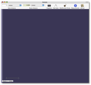
The interface of Meander is very clean and straightforward as well. As the following screen shot shows, you’re presented with a simple toolbar across the top, a sheet of clear-blue “acetate” which serves as your overlay on which you’ll plot your route, and a small scale “widget” that is used to help Meander accurately report the distances of points plotted on the map you’re working with. The scale at the bottom can be relocated and stretched to fit the scale of the map your acetate is floating over, and the Scale Distance drop down menu allows you to specify the distances in miles, kilometers, meters, feet, inches, centimeters and millimeters. Setting these properly before you start your plots ensures accurate measurements.
Some of the more interesting features of Meander are positioned on the toolbar by default: Snapshot is used to “link” a map image to the route plotted on the acetate and Journal is a simple notepad, but it can be used to type up interesting information about the route and store those notes within the route file. To keep things fun, Meander presents your journal in a top-bound spiral notebook format just like you might stuff in your back pocket before trudging off to hike in the woods.
Using the Software
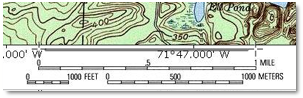
My initial thought was to grab a couple screen shots from Google Maps to get a feel for how Meander worked and, while that was okay, it failed to show the uniqueness of this application. So I turned to a Google Image search to find a few topographical maps to play around with. Surprisingly, this turned out to be the hardest thing about using Meander. I could not find a topo map with a scale on it! When I finally did, though, I fired up Meander and got down to business.
To begin plotting out a route or take measurements, simply place and size the open Meander window over the map you want to work with. That map could be in a web browser, Preview, Photoshop, iPhoto, or even your Mac’s wallpaper. It doesn’t matter. What does matter is that you can see the scale on the original map because, as I mentioned above, you want to ensure you’re working at the right proportions. In a wonderful bit of usability, Meander’s scale can be dragged anywhere on the acetate and then easily resized to the proper dimensions – even at an angle. I noticed the location of Meander’s scale tended to wander around the window a bit – especially after retrieving saved routes – but it never lost its dimensions, so accuracy was never a concern.
Once the program is calibrated to your map, you can start plotting your paths. Simply pick a starting point and click. Then each subsequent click plots another point at the location clicked.
When you’re ready to end your route, double click to place an end-point. The entire time you’re plotting the path, Meander is keeping track of distances based on what you told it about the map.
In this example, I switched the line style to something a bit more visible than the default thin black line which was nearly impossible to locate on the topographical map. In my testing, it appears Meander remembers your preference for line style which is really nice.
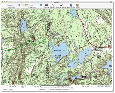
You can see, based on the scale and Scale Distance setting,
that this plotted route is just over 1.8 miles long. A nice feature of Meander
is the ability to “continue” the route from the last point added. So if I
decided that marching scouts two miles through these hills was not enough, I
could add a couple more miles before distributing the route to everyone.
I found the editing of plots made on the map to be twiddly. I could do it, but unlike the rest of the program, this didn’t feel as natural as it should. I also had issues when I wanted to change the route by adding points to it. I found the only way to do this was not to click the line to insert a new point as you might expect, but to add a waypoint and then convert it to a regular point. I would also like to see more of these functions moved from the menus to the context menus, because in this example of adding a point, I had to use the “Route” menu to add the waypoint, but then I had to right-click that new point to convert it.
After spending so much time plotting out your route, the last thing you want to have happen is lose the map you traced. Meander takes care of that problem with the Snapshot button. Pressing Snapshot embeds a picture of whatever is under the acetate within your saved route. Sharp-eyed users will notice that after clicking Snapshot, the button changes to “Clear Acetate”. If you have not yet saved the route with an embedded snapshot, don’t press Clear Acetate unless you’re absolutely sure you want to lose the picture linked to your route.
After spending a considerable time plotting out a route, I clicked Clear Acetate to see what it would do and quickly discovered it is a way to return to the non-snapshot view with no undo. I would like to see a warning pop up before clearing the acetate, though I expect once you’ve clicked that button, you aren’t likely to click it again unless you mean to! Though this does not touch your route, it’s still a critical feature to be aware of when working with maps that you found on the Internet and maybe didn’t save a local copy of thinking that you had it locked up with the Snapshot feature. Of course there are “outs” to this mistake. The most tedious is trying to locate the map you used to plot your route and then lining your route up with it once again. The other is to open up a saved copy of your route which should put you back where you were – provided you haven’t saved over it in the interim.
In one testing session of Meander, I encountered a bit of trouble with the Snapshot button. It would not automatically switch to Clear Acetate after taking the snapshot as it had on previous tests. Instead, it would just keep taking snapshots. I thought for a moment that I had been misunderstanding the way Snapshot worked, but a quick restart of the program restored its functionality.
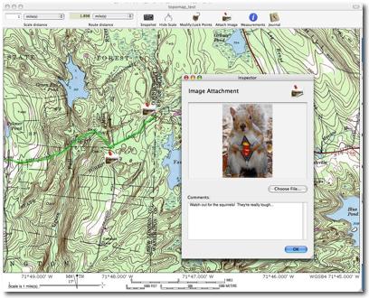
A cool feature of Meander is the ability to attach images to your routes. Let’s say you’re plotting out a hike for a group of scouts and you want to point out a cool rock formation or help them identify flora and fauna they might encounter on the trail. You can attach images of those objects along with some comments to help explain what they’re seeing.
I ran into an annoying problem when I used the Attach Image function to put interesting points on my route. I found that if I deleted an attached image and saved the route, the attached image would reappear again the next time I loaded the route. I could move it or make changes to it and those changes would stick through the saves, but I could not delete it without it popping back up again the next time I loaded the map.
When your route is complete, you’re likely going to want to share that route with friends. This is where the Export comes in. Unfortunately, export is somewhat hobbled at this point. In my testing, exporting your map to a JPEG saves the image and the plotted route, but nothing else. There scale is there, but no distance information and, more importantly, no image attachments – or even their locations.
When I tested the Export for E-mail command I had higher hopes, but those were quickly dashed when I realized that the map could only be used by other Meander users. In all other respects, however, Export for E-mail worked as promised: As long as the person you’re sending the map to owns Meander, they’ll be able to open the route, check out your attached images and even make changes to the route to suit their needs.
It seems to me that the Export function could be made much more useful if it would have an Export to HTML function that would generate a “Web 2.0” page containing the snapshot, the route and all attached images and present them all using CSS and JavaScript so that image attachments could be clicked to reveal the photo and comments contained within. This would allow me to upload the interactive route to my web site or package it together to e-mail to someone who doesn’t own Meander.
As long as I’m wandering down “Wishlist Lane” I thought more than once that an Import Google Map feature would be great. Imagine pasting a link to a Google Map into Meander and letting it locate and grab the snapshot without needing to find and line-up the map yourself. I think this would be handy for anyone who regularly gets Google Map links in e-mail and needs to mark up those routes.
The joy of Meander is that, if you can apply a scale to an image, you can measure and plot points on it, so after playing around with various maps, it dawned on me that perhaps Meander could be used for things outside the intended scope of the program such as measuring objects in a graph or an architectural drawing, sizing up family members in a photo, or even applying its plotting and measuring abilities to small interior decorating projects around the house.
Snagging a somewhat reluctant volunteer, I asked my daughter to pose with a yard stick at the far end of the living room to see what else I could make Meander do.
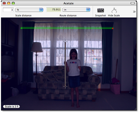
I placed Meander’s scale on the ends of the yard stick, set
the scale distance to 3 feet and the route distance to inches. With a couple
points plotted on the acetate, I could get a rough estimate of the window’s
width of 74 inches. I realize this is not a precision measurement, but for quick estimating it would work
just fine.*
This silly exercise highlights another limitation of Meander I encountered when using it on maps however: what if I want to plot multiple routes on one map? Unfortunately you can’t at this time. The ability to mark two potential hiking trails on a map in two different colors (“easy” and “difficult” for instance), or, in my crazy interior decorating example, measuring not only the entire width of the window, but the height as well, is something I think is sorely needed. I hope this will be added at some point in the future
Conclusion
As you can tell from my rating, I like Meander a lot. I was torn between 3 ½ stars and 4 stars, but eventually decided on the higher rating because the sheer versatility of Meander far outweighs the weird bits and bobbles I found working with this program. Looking in the Meander, About screen, it’s easy to see the program is in active development and a number of updates and new features have been released recently. With that in mind, I’m sure most of the buggies I encountered will be squashed pretty rapidly.
Recommendation
If you’re a map geek like me, I don’t think you can go wrong to drop twenty bucks on Meander. I found the program to be very intuitive and useful and feel it would make a great addition to anyone’s toolbox.
*After reviewing a final proof of the article (and measuring the windows seen in the picture for blinds this past weekend), I realized the measurement of 74 inches in this alternative use experiment is considerably off the mark. Of course this is because my daughter is standing approximately 3 - 4 feet in front of the window and not immediately alongside it. Because I still feel Meander could be used for approximating measurements outside of its intended uses, I decided to leave this part of the review intact rather than excise it for no other reason than to emphasize the program's flexibility. If you decide to use Meander for things other than maps, please take into account the basic geometry principles than I have, apparently, forgotten.